
📅 Last updated: 22.11.2026
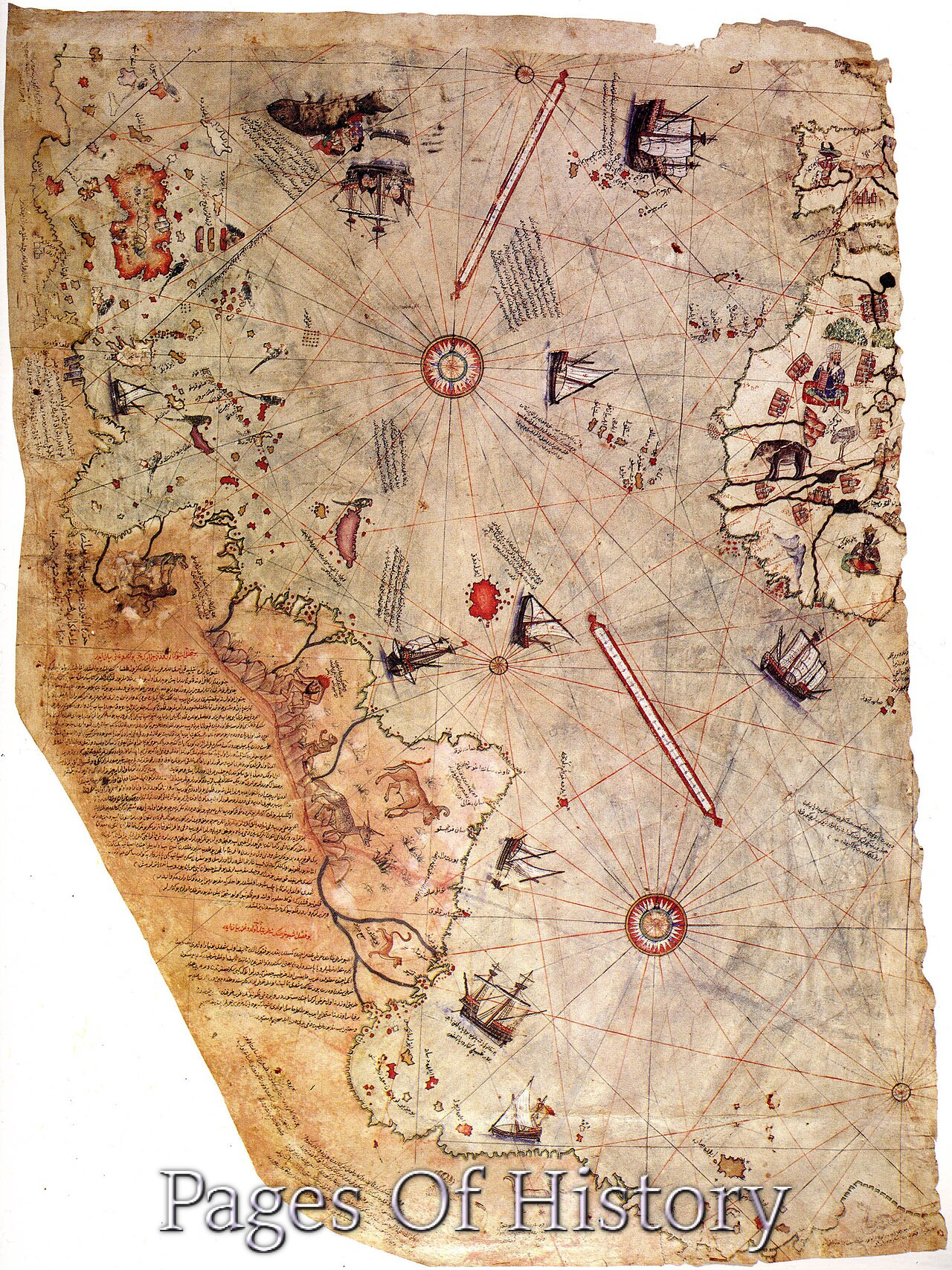
The Piri Reis map is one of the most debated artifacts in the history of cartography: a surviving fragment of a world map drawn on gazelle-skin parchment in 1513 by the Ottoman admiral and chart-maker Piri Reis. What makes it extraordinary is the strip of coastline along its lower edge that many historians, geographers, and enthusiasts have identified as the Atlantic coast of South America and, controversially, a projection of Antarctica—a continent not formally sighted by documented European expeditions until 1820. The map is real, it is Ottoman, it is dated, and it is genuinely strange. Understanding what it actually shows requires separating the parchment from the mythology that has grown around it.
The Piri Reis map is a 1513 Ottoman world chart, of which only the western third survives, showing the Atlantic Ocean, the Americas, and West Africa. Its southern coastline has been interpreted by some researchers as depicting part of Antarctica, but mainstream historians hold that it most likely represents a distorted or legendary southern landmass, possibly derived from Ptolemaic and medieval sources, rather than a genuine pre-modern sighting of the Antarctic continent.
- What Is the Piri Reis Map, and Who Made It?
- What the Map Actually Shows
- Why Antarctica Is the Hard Part: The Historical Problem
- The Piri Reis Map in the History of Cartography
- How the Piri Reis Map Became a Legend
- What the Piri Reis Map Teaches About Evidence and Myth
- The Lasting Legacy of the Piri Reis Map
What Is the Piri Reis Map, and Who Made It?
Piri Reis (c. 1465/70–1553) was an Ottoman corsair, naval commander, and cartographer whose full name was Muhiddin Piri. He was the nephew of Kemal Reis, a celebrated Ottoman admiral who commanded fleets for Sultan Bayezid II. Piri served in the Ottoman navy for decades, fought in the Ottoman–Venetian wars, and eventually rose to the rank of admiral (reis). He was executed in 1553 after a failed campaign against the Portuguese in the Persian Gulf, but his reputation rests on his cartography—above all his Kitab-ı Bahriye (Book of the Sea), a navigational atlas of the Mediterranean, and the world map of 1513.
The map fragment that survives today is held in the Topkapı Palace Museum in Istanbul. It was rediscovered in 1929 by Halil Edhem, director of the Topkapı museums, during cataloguing work. The parchment measures roughly 90 by 63 centimeters and represents only about one-third of the original chart—the western portion. The eastern sections, which would have shown Europe, Asia, and much of Africa, are lost. A colophon in Ottoman Turkish on the map states that it was drawn by Piri ibn Haji Mehmed, known as Piri Reis, in the year 919 AH (1513 CE), in Gallipoli.
The Sources Piri Himself Listed
In the marginal notes written on the map—an unusual and valuable feature—Piri Reis explained his method. He stated that he had consulted about twenty charts and mappae mundi, including:
- Eight charts (or map sheets) from the time of Alexander the Great, which he described as “Jaferiye” charts—likely a reference to Ptolemaic or late antique geographical traditions.
- An Arab map of India.
- Charts drawn by four Portuguese infidels, showing parts of India and China.
- A map made by Christopher Columbus, which Piri claimed had fallen into Ottoman hands after a Spanish ship was captured by his uncle Kemal Reis.
This last claim is crucial. Piri explicitly credited Columbus for the information on the New World, and modern scholarship has generally accepted that the Caribbean and South American outlines on the map derive, directly or indirectly, from Columbus’s own charts or those of his contemporaries. The map is thus a synthesis of Ottoman, Arab, Portuguese, and Spanish knowledge—not a product of secret ancient wisdom.
What the Map Actually Shows
The surviving fragment depicts, from right to left (east to west): the coast of West Africa and the Iberian Peninsula at the far right; the Atlantic Ocean; the Caribbean islands—including Hispaniola, Cuba, and others—drawn with recognizable accuracy; the northern coast of South America; and, along the bottom, a long coastline that curves south and east, populated with animals, ships, and legends.
The Caribbean islands are the strongest evidence of Columbus-derived information. Hispaniola and Cuba appear in roughly correct relative positions, and Piri’s notes describe them as discovered by “the Genoese infidel” Columbus. The South American coast is likewise recognizable to historians of cartography, though distorted by the projection and by the limitations of Piri’s sources.
The southern coastline is where the controversy lies. It runs along the bottom of the map, and its eastern end bends sharply toward the equator. Some interpreters have read this as the coast of Antarctica, specifically the Queen Maud Land and the Antarctic Peninsula, and argue that it matches the subglacial topography revealed by modern seismic surveys. Others read it as a continuation of South America, distorted by projection, or as a representation of a hypothetical southern continent derived from classical geography.
Why Antarctica Is the Hard Part: The Historical Problem
The Antarctic continent was first sighted, on the best evidence, in 1820, when the Russian expedition of Fabian Gottlieb von Bellingshausen and Mikhail Lazarev approached the Antarctic ice shelf. Earlier navigators—James Cook in the 1770s—had crossed the Antarctic Circle but never sighted land. If the Piri Reis map genuinely depicts Antarctica’s coastline, it would overturn a substantial body of historical geography.
There are several reasons mainstream historians are skeptical of the Antarctic reading:
- No source claims it. Piri Reis’s own notes describe his sources as Ptolemaic charts, Arab maps, Portuguese charts, and Columbus’s map. None of these would have included Antarctica, and Piri never claims to have drawn a southern continent.
- The projection is ambiguous. The map’s southern section is drawn in a style that may be a continuation of the South American coast, distorted by the chart’s projection and by the limitations of the parchment.
- Classical geography expected a southern landmass. Ptolemy and medieval mapmakers posited a Terra Australis Incognita—a southern landmass required to balance the northern continents. A cartographer in 1513 would have expected such a landmass to exist and might have drawn it from inherited tradition rather than observation.
- Antarctica’s ice cover. Antarctica has been glaciated for millions of years. Any pre-modern sighting would have seen ice and coastline, not the subglacial terrain that some researchers claim to match.
The most careful scholarly treatments—including work by the historian of cartography Gregory McIntosh—conclude that the southern section of the map most plausibly represents a combination of South American coastline and a speculative southern landmass, not a genuine depiction of Antarctica.
The Piri Reis Map in the History of Cartography
Regardless of the Antarctic question, the map is a remarkable document of early sixteenth-century global knowledge. In 1513, only twenty-one years after Columbus’s first voyage and fifteen years after Vasco da Gama reached India, a cartographer working in Gallipoli could synthesize Spanish, Portuguese, Arab, and classical sources into a single world chart. That fact alone is significant: it shows how rapidly new geographical information circulated across political and religious boundaries in the early modern Mediterranean.
Ottoman Cartography and the Wider World
Piri Reis was not an isolated figure. Ottoman cartographers and navigators were deeply engaged with the wider world, and the Kitab-ı Bahriye, presented to Sultan Suleiman the Magnificent in 1521 and revised in 1526, became a standard navigational reference. The 1513 map was part of this broader Ottoman engagement with Atlantic and Indian Ocean geography, driven by trade, warfare, and diplomacy. The Ottomans were rivals of the Portuguese in the Indian Ocean and of the Spanish in the Mediterranean, and accurate charts were strategic assets.
The map also illustrates the mechanics of knowledge transfer. Piri’s claim that a Columbus chart was captured by Kemal Reis is plausible; Ottoman corsairs operated in the western Mediterranean and captured Spanish and Portuguese vessels. Charts were valuable prizes, and captured charts were copied and adapted. The Piri Reis map is thus a physical record of how geographical knowledge moved—by capture, copying, and synthesis—in an age before printed maps were common.
| Date | Event | Significance |
|---|---|---|
| c. 1465/70 | Birth of Piri Reis | Ottoman corsair and cartographer; nephew of Admiral Kemal Reis |
| 1492 | Columbus’s first voyage | Source of New World information later used by Piri |
| 1513 | Piri Reis draws his world map | The surviving fragment; dated 919 AH in Gallipoli |
| 1517 | Ottoman conquest of Egypt | Expanded Ottoman access to Red Sea and Indian Ocean navigation |
| 1521/1526 | Kitab-ı Bahriye presented and revised | Piri’s navigational atlas of the Mediterranean |
| 1553 | Execution of Piri Reis | After a failed campaign against the Portuguese in the Persian Gulf |
| 1820 | First sighting of Antarctica | Bellingshausen–Lazarev expedition |
| 1929 | Rediscovery of the map | Found at Topkapı Palace by Halil Edhem |
How the Piri Reis Map Became a Legend
The modern mythology around the map owes much to the mid-twentieth century. In 1956, a Turkish naval officer, Halil Edhem’s successor as director of the Topkapı, sent copies of the map to the United States for study. The map came to the attention of Arlington H. Mallery, an engineer and amateur cartographer, who argued in the 1950s that the southern coastline matched the subglacial topography of Antarctica as revealed by seismic surveys. Mallery’s claims were popularized in the 1960s by Charles Hapgood in his book Maps of the Ancient Sea Kings (1966), which argued that the map preserved knowledge of a lost advanced civilization that had mapped Antarctica before the Ice Age.
Hapgood’s thesis was influential in popular culture and was later cited by pseudoscientific authors, including Erich von Däniken, who linked the map to extraterrestrial visitors. These claims have been repeatedly examined and rejected by historians of cartography and geographers. The core problems remain: the map’s sources are documented, its southern section is ambiguous, and the claimed match to subglacial topography depends on selective comparison and on ignoring the map’s projection and distortions.
What Responsible Scholarship Says
Mainstream scholarship—represented by historians such as Gregory McIntosh, and by the cartographic literature more broadly—treats the map as a genuine and valuable early modern artifact whose southern section is best explained by the conventions of contemporary geography rather than by lost ancient knowledge. The map’s importance lies in what it reveals about the circulation of knowledge in the early sixteenth century, not in claims about prehistoric civilizations.
What the Piri Reis Map Teaches About Evidence and Myth
The map is a case study in how historical artifacts acquire meanings their makers never intended. Piri Reis drew a world chart using the best available sources—Ptolemaic tradition, Arab geography, Portuguese charts, and a captured Spanish map. He annotated it in Ottoman Turkish with notes on his sources. He did not claim to have seen Antarctica, and he could not have. The Antarctic reading of the map emerged in the 1950s, when Cold War-era geophysical surveys of Antarctica provided new data that enthusiasts then projected back onto a sixteenth-century document.
The responsible approach is to ask what the map’s maker intended and what his sources were. Piri’s own notes provide the answer: he was synthesizing known geographical knowledge, including a speculative southern landmass inherited from classical geography. The map is remarkable precisely because it shows how much was known—and how much was inferred—in 1513.
The Lasting Legacy of the Piri Reis Map
The Piri Reis map remains one of the most important surviving documents of early modern cartography. It records the moment when Ottoman, Arab, Portuguese, and Spanish geographical knowledge converged in a single chart, and it preserves evidence of how that knowledge traveled—through captured charts, copied manuscripts, and the practical needs of navigation and warfare. Its rediscovery in 1929 and its later fame as an “Antarctic” map have made it a cultural icon, but its real significance is more grounded: it is a window into the intellectual world of the sixteenth-century Mediterranean, where a cartographer in Gallipoli could draw the coast of Brazil and the islands of the Caribbean from sources that had crossed oceans and empires.
The Antarctic controversy will likely persist in popular culture, but the historical record is clear enough. The Piri Reis map is not proof of a lost civilization or of prehistoric Antarctic exploration. It is proof of something more interesting: that in 1513, the world’s geographical knowledge was already global, contested, and rapidly changing—and that a single Ottoman admiral could capture that moment on a piece of gazelle parchment.